North Old Town Alexandria Virginia

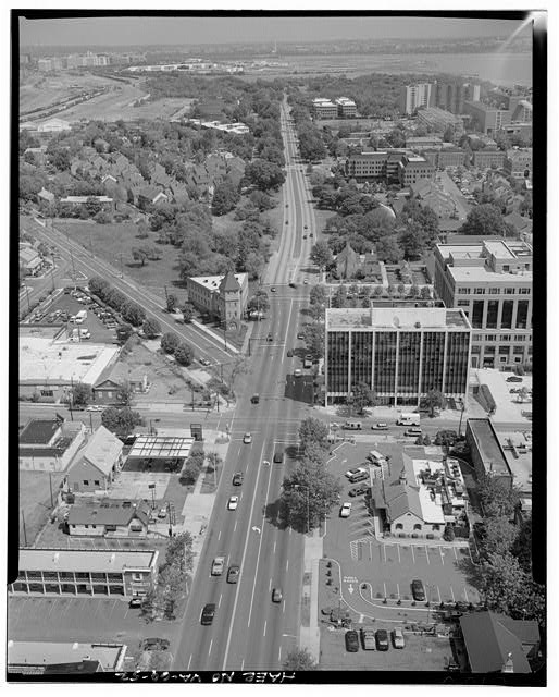
UPDATED (11:15 AM): The post title originally said the 1960s. A reader noted that the turret style building on the corner of Washington Street and Powhatan Street (at the start of the fork you see in the picture) was not there as early as 1972. I re-checked the photo array and have updated the post based on his comments.

Vincent wrote:

that corner section with the steeple was not there in 68 69 or 1972 when i left alexandria and went in the Navy . . .

UPDATED (1:45 PM): The post title originally said the 1960s then was changed to the 70s. I have changed the post title again as another reader astutely noted the AFBA building located center right in the photo didn’t come online until the late 80s. Before posting another aerial shot, will research the area of the photo a little more rather than trusting the source.

Agnes wrote:

The AFBA building at right center was not built until late 80s early 1990s

Via the Library of Congress, here’s an aerial view of the northern end of Old Town Alexandria. Virginia taken during a historic American landscape survey of the area that started in the late 1960s.

What looks the same to you now? What is in the area now that is not in the photo below? Discuss in the comments below.

This digital/virtual model shows all four options the Potomac Yard Implementation Group is currently looking at for the new Metrorail station. In the model above, you can see how the station looks from the parkway both north and southbound on the left and in summer and fall/winter. The right side of the screen gives you a Google Earth and Good Maps view of where you are located on the left.

The model is on display now in City Hall for two weeks so you have the chance at seeing it up close.

When you see option D above – here’s what the reaction was at the meeting last night.


For our morning links, while you slept, showered, shaved, and got your Starbucks, we scanned the local papers, blogs, and websites to find the most interesting stories in them you might have missed.

(more…)

The .US National 12K race returns to the Alexandria this Sunday, November 16, in Old Town for the 2nd year with a new course along the Parkway! Runners of all ages and abilities can choose between a 12K, a 1-mile speed test, or a kids fun run.

For more information about the race click this link. There’s still time to register! Click this link to register. You can view parking restrictions for this race at this link (Saturday AND Sunday).

Here are the road closures. Don’t say we didn’t warn you…

Road Closure Information

Saturday, November 15 (Race setup) 6:00 AM – 12:00 PM

  • North Union Street – from Oronoco Street to Pendleton Street
  • Pendleton Street – from North Fairfax Street to North Union Street
  • Oronoco Street – from North Union Street to Wests Point

Sunday, November 16 ) (Race Day) 6:00 AM – 12:00 PM

  • North Union Street – from Franklin Street to Pendleton Street
  • Pendleton Street – from North Fairfax Street to North Union Street
  • Franklin Street – from South Washington Street to South Union Street
  • South Washington Street – from Franklin Street to South Alfred Street
  • GW Memorial Parkway – from Northdown Road to South Alfred Street