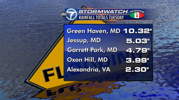
When it rains a lot and/or there are heavy rains like we got yesterday, Cameron Run, which runs down the Eisenhower Valley along Eisenhower Ave and toward the Huntington area across the Capital Beltway, tends to flood as you can see in this video (this video and this video too) on how that affects our Carlyle/Eisenhower East neighborhood. Huntington, across the Beltway can also get pounded (see here and here). During Tropical Storm Lee in September 2011, Alexandria first responders made 30 rescues in the Telegraph Road/Eisenhower Ave area due to flash flooding from Cameron Run.

Cameron Run very high under the Capital Beltway

Cameron Run very high under the Capital Beltway – June 28, 2013

Cameron Run at a high water mark - June 28, 2013

Cameron Run at a high water mark – June 28, 2013


The National Weather Service has issued the following Flash Flood Watch until 6:00PM this evening June 18, 2013.

SHOWERS AND ISOLATED THUNDERSTORMS WILL CONTINUE TO PRODUCE
  MODERATE TO HEAVY RAINFALL THROUGH THE REST OF THE
  AFTERNOON...PRIMARILY INTERSTATE 95 AND EAST. ONE TO TWO
  ADDITIONAL INCHES COULD CAUSE MORE FLOODING OR FLASH FLOODING.

PRECAUTIONARY/PREPAREDNESS ACTIONS...

A FLASH FLOOD WATCH MEANS THAT CONDITIONS MAY DEVELOP THAT LEAD
TO FLASH FLOODING. FLASH FLOODING IS A VERY DANGEROUS SITUATION.


Rain cloud passing over Carlyle

Interesting Area News

While you slept, showered, shaved, and got your Starbucks, we scanned the local papers, blogs, and websites to find the most interesting stories in them you might have missed.

  • Mother nature goes easy on the humidity today, will she bring us weekend showers? (Capital Weather Gang)
  • Virginia has become a hub for risky car loans (Washington Post)
  • Virginia ABC stores are printing some interesting information on your receipt (WTOP)
  • Still haven’t taken part in restaurant week? Here are 15 dining options for you (WUSA 9)
  • Heading out toward the I-66 corridor this weekend? Read this –> (WJLA)
  • ‘Southeast Jerome’ retires from pro football with grace, style, & a lot of memories (The Insider)
  • Heading out on Metrorail this weekend? Here’s what you need to know (Old Town Alexandria Patch)
  • Dog owners – Don’t miss the FINAL ‘Yappy Hour’ of the summer tonight @ Artfully Gifts (Community events calendar)

The National Weather Service has issued the following Flash Flood Watch until 11:15 this evening.

AT 812 PM EDT…NATIONAL WEATHER SERVICE DOPPLER RADAR INDICATED
VERY HEAVY RAINFALL CAPABLE OF PRODUCING FLASH FLOODING FROM A
THUNDERSTORM OVER THE WARNED AREA. RAINFALL RATES OF ONE TO TWO
INCHES PER HOUR CAN BE EXPECTED WITH THIS STORM.

* SOME LOCATIONS THAT WILL CONTINUE TO BE AFFECTED BY THE HEAVY RAIN
INCLUDE ALEXANDRIA…ARLINGTON…BALLSTON…DUMFRIES…FORT
BELVOIR…FRANCONIA…LORTON…NEWINGTON…ROSSLYN…
SPRINGFIELD…WOODBRIDGE…HYATTSVILLE…LANDOVER…LANGLEY
PARK…ADAMS MORGAN…ANACOSTIA…GEORGETOWN…AND DOWNTOWN
WASHINGTON.

Instructions: EXCESSIVE RUNOFF FROM HEAVY RAINFALL WILL CAUSE FLOODING OF SMALL CREEKS AND STREAMS…URBAN AREAS…HIGHWAYS…STREETS AND UNDERPASSES AS WELL AS OTHER DRAINAGE AREAS AND LOW LYING SPOTS. A FLASH FLOOD WARNING MEANS THAT FLOODING IS IMMINENT OR OCCURRING. IF YOU ARE IN THE WARNING AREA MOVE TO HIGHER GROUND IMMEDIATELY. RESIDENTS LIVING ALONG STREAMS AND CREEKS SHOULD TAKE IMMEDIATE PRECAUTIONS TO PROTECT LIFE AND PROPERTY. DO NOT ATTEMPT TO CROSS SWIFTLY FLOWING WATERS OR WATERS OF UNKNOWN DEPTH BY FOOT OR BY AUTOMOBILE.

Flash flooding is nothing to sneeze at. For example, see this video from the recent Tropical Storm Lee deluge.