

For our Sunday Brunch notes, while you slept, showered, shaved, and got your Starbucks, we scanned the local papers, blogs, and websites to find the most interesting stories in them you might have missed.



For our Sunday Brunch notes, while you slept, showered, shaved, and got your Starbucks, we scanned the local papers, blogs, and websites to find the most interesting stories in them you might have missed.

Image via Red Brick Town Flickr Pool by Bill, on Flickr
For our morning notes, while you slept, showered, shaved, and got your Starbucks, we scanned the local papers, blogs, and websites to find the most interesting stories in them you might have missed.
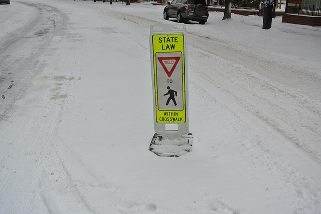
We told you it’s going to get colder starting tomorrow but, will it snow? It’s not looking like it will in Alexandria but, in the western areas of Northern Virginia, the National Weather Service says there is a slight chance for places like Fairfax on Thursday night. A good guy to follow on weather-related items for Alexandria is Del Ray’s own Russ Adams on Twitter.
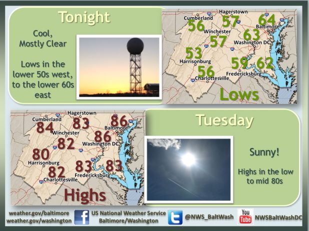
It can’t get any more pleasant than this in the D.C. Metro area in late August now can it? Warmer weather is on the way though…
High pressure keeps pleasant weather in place tonight and Tuesday. Enjoy! #dcweather #mdwx #vawx #wvwx http://t.co/O4qszUTcuC
— NWS DC/Baltimore (@NWS_BaltWash) August 25, 2014
A Special Weather Statement is in effect from the National Weather Service for the metropolitan Washington area, including the City of Alexandria, from NOW through 8:45PM today (06/11/2014).
…SEVERE THUNDERSTORMS LIKELY THIS AFTERNOON AND EVENING ALONG
WITH THE POTENTIAL FOR ISOLATED TORNADOES…WITH TEMPERATURES REACHING THE MID-TO-UPPER 80S WITHIN AND SOUTH
OF THE WASHINGTON DC METROPOLITAN AREA…THE REGION IS UNDER THE
THREAT OF SEVERE THUNDERSTORMS THIS AFTERNOON AND EVENING. SOME OF
THESE STORMS WILL LIKELY CONTAIN DAMAGING WIND…FREQUENT CLOUD-
TO-GROUND LIGHTNING… AND LARGE HAIL. ADDITIONALLY…TORNADOES
ARE POSSIBLE IN A FEW OF THE STRONGEST THUNDERSTORMS. THE MOST
LIKELY TIME FOR SEVERE WEATHER IS BETWEEN 400 PM AND 800 PM EDT.THE AREA MOST VULNERABLE FOR SEVERE WEATHER IS NORTH OF INTERSTATE
64 ACROSS VIRGINIA`S NORTH-CENTRAL PIEDMONT AND WEST OF
INTERSTATE 95 SOUTH OF THE CITY OF BALTIMORE MARYLAND TO
FREDERICKSBURG VIRGINIA. THIS INCLUDES THE GREATER WASHINGTON DC
AND BALTIMORE METROPOLITAN AREAS…HAGERSTOWN MARYLAND…THE
NORTHERN AND CENTRAL SHENANDOAH VALLEY…AND CHARLOTTESVILLE VIRGINIA.RESIDENTS AND VISITORS TO THIS REGION…ALONG WITH MARINERS ON THE
CHESAPEAKE BAY AND TIDAL POTOMAC RIVER…SHOULD HAVE AN INCREASED
AWARENESS OF THE THREAT OF HAZARDOUS WEATHER THIS AFTERNOON AND
EVENING.IF A SEVERE WEATHER WARNING IS ISSUED…SEEK SHELTER
INDOORS IMMEDIATELY…PREFERABLY IN A BASEMENT OR THE LOWEST LEVEL
OF A STURDY BUILDING. IF YOU ARE IN A BOAT…SEEK SAFE HARBOR
IMMEDIATELY.

While you slept, showered, shaved, and got your Starbucks, we scanned the local papers, blogs, and websites to find the most interesting stories in them you might have missed.

AAA Travel projects 36.1 million Americans will journey 50 miles or more from home during the Memorial Day holiday weekend, a 1.5 percent increase from the 35.5 million people who traveled last year. Kicking off the summer driving season, more than eight in ten travelers will be driving to their destinations. The Memorial Day holiday travel period is defined as Thursday, May 22 to Monday, May 26.


... "Pin It")


